Preview
Identifier
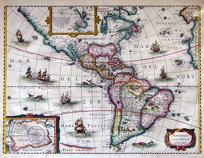
Map 1a
Creation Date
1631
Description
Original plate 1618, this published version 1631
published version Henricus Hondius
37 x 49 cm., hand colored probably from the Mercator-Hondius Atlas
The copperplate that produced this map was originally prepared by Jodocus Hondius Jr. in 1618. It was published in 5 states, or versions, three with decorative borders and two without. This map, the third state with a decorative border, was published by Henricus Hondius in 1631. It is an appropriate representation of what was known about English North and South America during the first quarter of the Seventeenth Century. This map contains insets of Greenland and the South Pole. It depicts California as a peninsula and only shows one Great Lake.
Keywords
Hondius, Jodocus, Hondius, Henricus, America Noviter Delineata, Seventeenth Century maps, ancient maps, Carlton D. Weaver Map Collection, Early U.S. maps
