Preview
Identifier
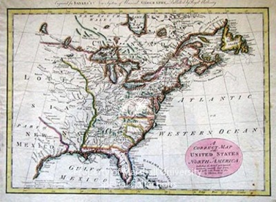
Map11-sm
Creation Date
1784
Description
1784/85
33 x 44 cm., hand colored
This map covers the thirteen United States, Louisiana, and parts of Canada, Florida, and Mexico. It shows the boundaries, towns and Cities, forts, Indian villages and tribal territory, mines, grasslands and relief, as well as a few historical notes. Thomas Bowen’s distinguished father was the official engraver for King George II. He engraved for his father’s atlas, British American Plantations and Captain Cook’s Royal English Atlas, 1767; along with several other atlases.
Keywords
Thomas Bowen, Eighteenth Century maps, ancient maps, Carlton D. Weaver Map Collection, Correct map of the United States
