Preview
Identifier
Map7-sm
Creation Date
1754
Description
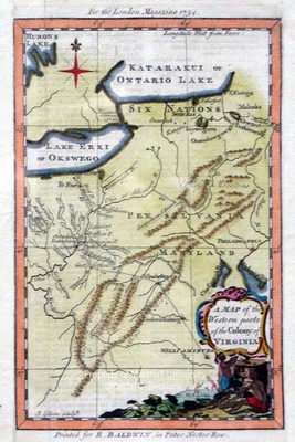
1754
20 x 12.5 cm., hand colored
This map depicts the area from western New York to, and including, Virginia, then west to the junction of the Ohio River and the Great Kanhaway or New River. A route or trail is shown from Williamsburg to Fredericksburg, thence to Winchester, the Gist settlement and Shanopins town. Two French forts are shown on the Ohio River. It is the first map to show upper Ohio Valley topography.
Keywords
Richard Baldwin, Early Virginia maps, Eighteenth Century maps, ancient maps, Carlton D. Weaver Map Collection, Early maps of western Virginia
