Preview
Identifier
Map13-sm
Creation Date
1796
Description
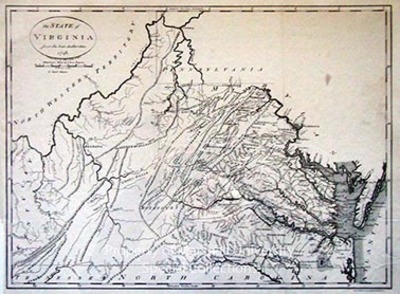
1796
47 x 34 cm.
This map shows the reduced boundaries of Virginia. Once its boundaries stretched west from the Chesapeake Bay to the Mississippi River, north up the Mississippi River to the Canadian line and southeast along the Great Lakes to Pennsylvania. This map reflects the January 2, 1781, Virginia General Assembly decision to cede to the Federal Government all its claims to the land northwest of the Ohio River. Further changes came in 1792, when Virginia counties south of the Ohio River and West of the Big Sandy became the Commonwealth of Kentucky. This is a high quality reproduction that adds depth to the collection.
Keywords
Jean Lattre, Eighteenth Century maps, ancient maps, Early Virginia maps, Carlton D. Weaver Map Collection, Andrew V. Graham Co., State of Virginia from the Best Authorities
