Preview
Identifier
Map12-sm
Creation Date
1784
Description
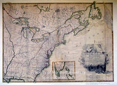
1784
76 x 55 cm.
Lattre dedicated this map to “His Excellency Mr. Benjamin Franklin,” who was the principal negotiator of the Peace Treaty which settled the boundaries of American Independence. This was the first French map of the newly created United States of America. Lattre borrowed generously from previously published maps and he seems especially to have favored John Mitchell’s 1775 Map of British and French Dominions of North America. This map is one of the most attractively designed and executed maps of the period and reflects the talent and skill of the artist-cartographer.
Keywords
Jean Lattre, Eighteenth Century maps, ancient maps, Carlton D. Weaver Map Collection, Donnelley & Sons
