Files
Download Full Text (12.9 MB)
Collection
0099: Cabell-Wayne Historical Society Collection
Institution
Marshall University Archives and Special Collections
Date
1-1-1865
Description
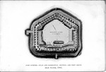
Fort Sumter, 1865, plan and horizontal section-six feet about high water, 18.5x12.5cm Fort Sumter as it was during the War, showing the effects of the bombardment by Maj. John Johnson, Engineer at Fort Sumter Publisher: Walker, Evans & Cogswell Co.,Charleston, S.C. Compliments of J. F. Weruer, Sullivans Island, S.C. Sergent Charles E. Walker, Battery M. 1 artillery, Sullevans Island, South Carlina This ground-plan of the Fort, as it was arranged before evacuation, shows changes as great as they were necessary, from its original plan. The only regions unchanged are the three lower casemates, opposite Fort Moultrie, near the eastern angle, and the entire line of casemates on the western or city-front. The greatest ruin and repair are seen in the two faces adjoining the main salient, and in the eastern or sea-front, and in the gorge. All these parts, being ruined, were covered over securely with earth. The greatest ruin was all along the sea-front, where the outer wall had been battered down to within three or four feet of the water's edge. A part of the original stone wharf is seen on the gorge. The new landing, required to be built under cover from the fire of the enemy, is seen on the western or city-front of the Fort. All the upper tier of casemates had been destroyed.
Format
Photograph
Type
Still Image
Usage Rights
Identifier
1975.0099.14.11.21
Recommended Citation
"Fort Sumter, 1865, plan and horizontal section-six feet about high water" (1865). 0099: Cabell-Wayne Historical Society Collection. 7.
https://mds.marshall.edu/cabell_wayne_hist_soc_collection/7
