Preview
Identifier
Map5-sm
Creation Date
1750
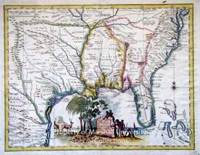
Description
1750
43 x 33 cm., hand colored
Guillaume De L’Isle was an important French Cartographer. His earlier 1718 map was the first detailed map of the Gulf region and the Mississippi. This is the first printed map to show Texas as a name. The detail and accuracy of Carta Geographical della Florida is typical of the 18th century French school. De L’Isle gave significant impetus to the advancement of cartography as a science by his strict standards of inclusivity.
Keywords
Guillaume De L’isle, Eighteenth Century maps, ancient maps, Carlton D. Weaver Map Collection, Early Florida map, Carta Geographical della Florida
